Click image for maximum view
Date: 02/08/07 - 11:26 AM
Added by: Joe Kriz
Dimensions: 640 x 427 pixels
Filesize: 57.59Kb
Comment: 1
Number of views: 7923
This is an aerial photo of part our 44 acre ranch. In the foreground is Hwy 3 and in the background is West Moffett Creek Road. Also in the background is Moffett Creek hugging the road. This is before we added the 20'x20' Office addition to the house. You can see the office in one of the newer areial photos. This photo was taken around 1995.

 Golden Clouds
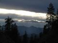 Evening Light
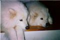 Bear Anne & Lobo Sue
  Gotcha!


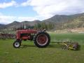 I.H. Tractor